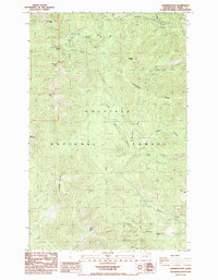
1985 Map of Sherman Peak
USGS Topo · Published 1985About this map
Sherman Pass serves as a critical high-altitude corridor through the Kettle River Range within the Colville National Forest. This mid-1980s provisional survey documents the primitive road and trail network that allowed access to prominent summits including Columbia Mtn, Sherman Peak, and Snow Peak. The drainage patterns are clearly defined by the diverging headwaters of Sherman Creek and Barnaby Creek, showing how the central ridge system dictates the movement of water across the terrain. Public recreation and land management are anchored by the Sherman Pass Campground, while the southern reaches of the quadrangle are dominated by the heights of White Mtn and the prominent Barnaby Buttes. The map reflects a landscape managed for wilderness and timber, with named features like Scalawag Ridge and Paradise Peak indicating the early nomenclature of the region's topographers.
Find a feature on this map
21 named features on this map. Tap any name to fly to it.
Don’t see what you’re looking for? This feature index may not catch every label — zoom into the map to look around manually.
Map Details
Editions of this 1985 Sherman Peak Map
This is the sole edition of this map. No revisions or reprints were ever made.
Other maps of this area

1904 · Republic
USGS Topo · 1:125,000

1936 · Marcus
USGS Topo · 1:96,000

1942 · Marcus
USGS Topo · 1:125,000

1948 · Republic
USGS Topo · 1:62,500

1948 · Sherman Peak
USGS Topo · 1:62,500

1951 · Sherman Peak
USGS Topo · 1:62,500

1951 · Republic
USGS Topo · 1:62,500

1952 · Twin Lakes
USGS Topo · 1:62,500

1953 · Seventeenmile Mtn.
USGS Topo · 1:62,500

1954 · Okanogan
USGS Topo · 1:250,000