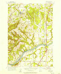
1954 Map of Sherwood
USGS Topo · Published 1957About this map
The Willamette River carves through the southern landscape of this mid-1950s survey, marking a distinct boundary between the growing communities of Washington and Clackamas counties. To the north, the town of Sherwood serves as a hub for the Southern Pacific railroad line, while nearby Six Corners indicates a complex local road network including the Pacific Highway West. The area is characterized by a mix of fertile lowlands like Onion Flat and the rising slopes of Parrett Mountain. Local history and genealogy are well-represented by several rural institutions, including St Paul School and its adjacent St Paul Cem, as well as the Pleasant Hill Cemetery and the Butteville Cemetery near the river. The map also captures the early footprints of settlements such as Wilsonville, Butteville, and Middleton, showing the integration of agricultural land with early suburban development along the Tualatin Valley Highway.
Find a feature on this map
69 named features on this map. Tap any name to fly to it.
Don’t see what you’re looking for? This feature index may not catch every label — zoom into the map to look around manually.
Map Details
Editions of this 1954 Sherwood Map
This is the sole edition of this map. No revisions or reprints were ever made.
Other maps of this area

1914 · Oregon City
USGS Topo · 1:62,500

1916 · Tualatin
USGS Topo · 1:62,500

1923 · Mount Angel
USGS Topo · 1:62,500

1939 · Molalla
USGS Topo · 1:62,500

1939 · Oregon City
USGS Topo · 1:62,500

1939 · Tualatin
USGS Topo · 1:62,500

1940 · Tualatin
USGS Topo · 1:62,500

1940 · Molalla
USGS Topo · 1:62,500

1940 · Mount Angel
USGS Topo · 1:62,500

1941 · Oregon City
USGS Topo · 1:62,500