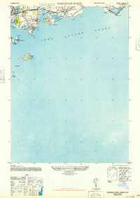
1947 Map of Sherwood Point
USGS Topo · Published 1947About this map
Sherwood Island State Park anchors this coastal survey, showing the Fairfield County shoreline just after the Second World War. The map details the intricate relationship between the marshy inlets and the developing residential communities of Compo, Owenoke, and Green Farms. Coastal infrastructure is well-defined, from the New York New Haven and Hartford railroad line running parallel to U.S. Route 1, to the various points and islands that define the Long Island Sound waterfront. Marine features such as Cockenoe Island, Peck Ledge, and Goose Island are plotted in relation to the mainland, while inland water bodies like Sherwood Pond and Mill Creek illustrate the natural drainage that shaped local development.
Find a feature on this map
34 named features on this map. Tap any name to fly to it.
Don’t see what you’re looking for? This feature index may not catch every label — zoom into the map to look around manually.
Map Details
Editions of this 1947 Sherwood Point Map
This is the sole edition of this map. No revisions or reprints were ever made.
Other maps of this area

1891 · Bridgeport
USGS Topo · 1:62,500

1892 · Norwalk
USGS Topo · 1:62,500

1893 · Bridgeport
USGS Topo · 1:62,500

1893 · Norwalk
USGS Topo · 1:62,500

1901 · Northport
USGS Topo · 1:62,500

1902 · Setauket
USGS Topo · 1:62,500

1903 · Northport
USGS Topo · 1:62,500

1904 · Setauket
USGS Topo · 1:62,500

1904 · Islip
USGS Topo · 1:125,000

1919 · Setauket
USGS Topo · 1:62,500