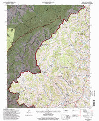
1994 Map of Sherwood
USGS Topo · Published 1998About this map
Sherwood and the surrounding highlands of western Watauga County are captured here just before the turn of the 21st century, showing a landscape defined by the winding course of Cove Creek. The map documents a scattered settlement pattern typical of the Appalachian high country, where life centers on small crossroads like Sugar Grove and Mast. Religious and educational heritage is evident in the presence of Cove Creek Church and the Cove Creek School, alongside several family-named topographic features such as Vaught Gap and Buckeye Knob. To the west, the boundary between Tennessee and North Carolina follows the high ridges of the Cherokee National Forest and Pisgah National Forest. The map traces a network of rural routes, including Us 421, connecting remote communities like Bethel and Reese through the gaps and hollows of the Blue Ridge mountains.
Find a feature on this map
93 named features on this map. Tap any name to fly to it.
Don’t see what you’re looking for? This feature index may not catch every label — zoom into the map to look around manually.
Map Details
Editions of this 1994 Sherwood Map
This is the sole edition of this map. No revisions or reprints were ever made.
Other maps of this area

1893 · Cranberry
USGS Topo · 1:125,000

1895 · Cranberry
USGS Topo · 1:125,000

1899 · Cranberry
USGS Topo · 1:125,000

1902 · Cranberry
USGS Topo · 1:125,000

1934 · Valle Crucis
USGS Topo · 1:24,000

1934 · Elk Park
USGS Topo · 1:24,000

1934 · Boone
USGS Topo · 1:24,000
1935 · Doe
USGS Topo · 1:24,000

1935 · Baldwin Gap
USGS Topo · 1:24,000

1935 · Doe Mountain
USGS Topo · 1:48,000