
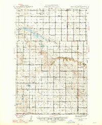
1947 Map of Sheyenne Lake
USGS Topo · Published 1947About this map
Governor Fred G. Aandahl and Chief Engineer J. J. Walsh oversaw the water conservation interests of this prairie landscape during the late 1940s, a period when the rural school district system remained the backbone of local society. The map reveals an incredible density of one-room schoolhouses, including Pioneer Sch No 4, Berlin Sch No 1, and Mertz Sch No 1, which served the scattered farmsteads across the Sheridan and Wells county line. Central to the geography is the Sheyenne River feeding into Sheyenne Lake, while the presence of a Coal Mine near Coal Lake points to the localized extraction industries of the era.
Find a feature on this map
38 named features on this map. Tap any name to fly to it.
Don’t see what you’re looking for? This feature index may not catch every label — zoom into the map to look around manually.
Map Details
Editions of this 1947 Sheyenne Lake Map
2 editions found
Other maps of this area

1930 · Drake
USGS Topo · 1:62,500

1940 · Aylmer
USGS Topo · 1:62,500

1941 · Selz
USGS Topo · 1:62,500

1945 · Manfred
USGS Topo · 1:62,500

1946 · Sheyenne Lake
USGS Topo · 1:48,000

1947 · Lincoln Valley
USGS Topo · 1:62,500

1948 · Manfred
USGS Topo · 1:62,500

1949 · Manfred SW
USGS Topo · 1:24,000

1950 · Manfred NW
USGS Topo · 1:24,000

1950 · Sheyenne Lake NE
USGS Topo · 1:24,000