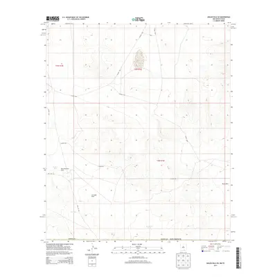
2013 Map of Shiloh Hills SE
USGS Topo · Published 2013About this map
Cornudas Draw and Wind Mountain Draw carve through this arid landscape in Otero County, where the terrain is marked by a complex system of seasonal water drainages and livestock infrastructure. The distribution of features like Bennett Tank, AAA Tank, and Brownfield Tanks indicates the primary importance of water management for ranching in this high-desert environment. A sparse network of unpaved roads, including Co Road F065 and Co Road F029, connects the various sections of the public land survey system, while Dell City Rd provides a primary route toward the southwest. The mapping of the North Draw and other intermittent streams illustrates the natural drainage patterns that define the region's topography between the t25s r16e and t26s r16e townships.
Find a feature on this map
16 named features on this map. Tap any name to fly to it.
Don’t see what you’re looking for? This feature index may not catch every label — zoom into the map to look around manually.
Map Details
Editions of this 2013 Shiloh Hills SE Map
This is the sole edition of this map. No revisions or reprints were ever made.
Other maps of this area

1951 · Dell City
USGS Topo · 1:62,500

1954 · Carlsbad
USGS Topo · 1:250,000

1954 · Van Horn
USGS Topo · 1:250,000

1955 · Cerro Diablo
USGS Topo · 1:62,500

1958 · Van Horn
USGS Topo · 1:250,000

1958 · Carlsbad
USGS Topo · 1:250,000

1969 · Lewis Canyon
USGS Topo · 1:24,000
1969 · Culp Draw
USGS Topo · 1:24,000
1970 · Shiloh Hills SE
USGS Topo · 1:24,000
1970 · Mc Veigh Hills
USGS Topo · 1:24,000