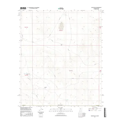
2017 Map of Shiloh Hills SE
USGS Topo · Published 2017About this map
The arid landscape of New Mexico along the Texas border is defined by its seasonal hydrology and scattered ranching infrastructure in this Otero County region. The terrain is marked by significant ephemeral drainage patterns, including the wide Cornudas Draw and North Draw, which navigate the high desert floor. Cattle ranching and land management are evident through named water catchments such as Bennett Tank, the Brownfield Tanks, and AAA Tank. These features are connected by a network of county roads, most notably Dell City Rd, which provides a transit link through this sparsely populated corner of the state. The map details the Public Land Survey System grid across multiple townships and ranges, grounding the geographic study in the legal boundaries of the American West.
Find a feature on this map
21 named features on this map. Tap any name to fly to it.
Don’t see what you’re looking for? This feature index may not catch every label — zoom into the map to look around manually.
Map Details
Editions of this 2017 Shiloh Hills SE Map
This is the sole edition of this map. No revisions or reprints were ever made.
Other maps of this area

1951 · Dell City
USGS Topo · 1:62,500

1954 · Carlsbad
USGS Topo · 1:250,000

1954 · Van Horn
USGS Topo · 1:250,000

1955 · Cerro Diablo
USGS Topo · 1:62,500

1958 · Van Horn
USGS Topo · 1:250,000

1958 · Carlsbad
USGS Topo · 1:250,000

1969 · Lewis Canyon
USGS Topo · 1:24,000
1969 · Culp Draw
USGS Topo · 1:24,000
1970 · Shiloh Hills SE
USGS Topo · 1:24,000
1970 · Mc Veigh Hills
USGS Topo · 1:24,000