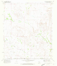
1970 Map of Shiloh Hills SE
USGS Topo · Published 1973About this map
McAnally Ranch and Bennett Ranch represent the sparse but vital human presence in this high-desert ranching landscape along the border of Otero and Hudspeth counties. Surveyed in the early 1970s, the map reveals a network of water sources essential for livestock survival in this arid environment, including the Sweet William Well, Tree Well, and Brownfield Tanks. The topography is defined by seasonal drainage patterns such as North Draw and the more prominent Cornudas Draw, while a jeep trail provides the primary means of navigating the undulating terrain. This map captures the intersection of New Mexico and Texas, showcasing a landscape where survival depended on the location of specific improvements like Bennett Tank and the Martin Lewis Well.
Find a feature on this map
15 named features on this map. Tap any name to fly to it.
Don’t see what you’re looking for? This feature index may not catch every label — zoom into the map to look around manually.
Map Details
Editions of this 1970 Shiloh Hills SE Map
This is the sole edition of this map. No revisions or reprints were ever made.
Other maps of this area

1951 · Dell City
USGS Topo · 1:62,500

1954 · Carlsbad
USGS Topo · 1:250,000

1954 · Van Horn
USGS Topo · 1:250,000

1955 · Cerro Diablo
USGS Topo · 1:62,500

1958 · Van Horn
USGS Topo · 1:250,000

1958 · Carlsbad
USGS Topo · 1:250,000

1969 · Lewis Canyon
USGS Topo · 1:24,000
1969 · Culp Draw
USGS Topo · 1:24,000
1970 · Mc Veigh Hills
USGS Topo · 1:24,000

1970 · Shiloh Hills
USGS Topo · 1:24,000