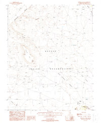
1988 Map of Shinumo Altar
USGS Topo · Published 1988About this map
The Shinumo Altar formation dominates the high desert terrain of the Navajo Indian Reservation in northern Arizona as recorded in the late 1980s. This survey illustrates a complex landscape of erosion and water management, where numerous drainages like Hogansaani Wash and Shinumo Wash carve through the Eminence Break. The land is characterized by massive sedimentary layers, forming distinct features such as the Gray Grass Bench and Limestone Ridge. Water security in this arid environment is evidenced by man-made infrastructure like the Salt Reservoir, Second Reservoir, and Corner Rock Reservoir. These sites, along with names like Rock Corral Bench, suggest a history of seasonal livestock grazing and land use. The southern portion of the map transitions into the higher elevation of Bodaway Mesa, marked by prominent landmarks like Tooth Rock and Corner Rock.
Find a feature on this map
18 named features on this map. Tap any name to fly to it.
Don’t see what you’re looking for? This feature index may not catch every label — zoom into the map to look around manually.
Map Details
Editions of this 1988 Shinumo Altar Map
This is the sole edition of this map. No revisions or reprints were ever made.
Other maps of this area

1886 · Echo Cliffs
USGS Topo · 1:250,000

1891 · Echo Cliffs
USGS Topo · 1:250,000

1954 · Shinumo Altar NE
USGS Topo · 1:24,000

1954 · Shinumo Altar SE
USGS Topo · 1:24,000

1954 · Nankoweap
USGS Topo · 1:62,500

1954 · Tanner Wash
USGS Topo · 1:62,500

1954 · Emmett Wash
USGS Topo · 1:62,500

1954 · Shinumo Altar
USGS Topo · 1:62,500

1956 · Marble Canyon
USGS Topo · 1:250,000

1959 · Marble Canyon
USGS Topo · 1:250,000