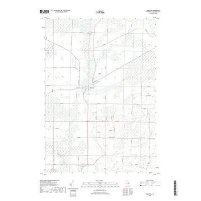
2018 Map of Shiocton
USGS Topo · Published 2018About this map
The Wolf River meanders through this Outagamie County landscape, its broad floodplains and surrounding wetlands defining the character of the village of Shiocton. The community is situated at the confluence of the Wolf and the smaller Shioc River, which enters from the northeast. This area shows a typical Wisconsin rural pattern where the town center, including the Po (Post Office) and the Shiocton Airport, is surrounded by long straight country roads named for local families, such as Rexford Ave and Thompson Rd. Notable historical sites for genealogists include Bovina Cem and Rexford Cem, both located south of the main village. The terrain is marked by significant marshland and low-lying areas, particularly along the river corridors, which have historically influenced the placement of roads like Co Rd P and Old Hwy 54.
Find a feature on this map
54 named features on this map. Tap any name to fly to it.
Don’t see what you’re looking for? This feature index may not catch every label — zoom into the map to look around manually.
Map Details
Editions of this 2018 Shiocton Map
This is the sole edition of this map. No revisions or reprints were ever made.
Other maps of this area

1955 · Embarrass
USGS Topo · 1:48,000

1955 · Appleton
USGS Topo · 1:24,000

1955 · Appleton
USGS Topo · 1:62,500

1955 · Seymour
USGS Topo · 1:62,500

1955 · Green Bay
USGS Topo · 1:250,000

1956 · New London
USGS Topo · 1:48,000

1969 · New London
USGS Topo · 1:24,000
1969 · Hortonville
USGS Topo · 1:24,000

1969 · Leeman
USGS Topo · 1:24,000

1969 · Bear Creek
USGS Topo · 1:24,000