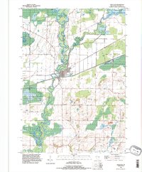
1992 Map of Shiocton
USGS Topo · Published 1996About this map
Wolf River meanders deeply through the center of this landscape, its serpentine oxbows and wetlands defining the development of Shiocton. The village is anchored by river-oriented recreation at Hamlin Park and Barker Park, while the surrounding marshlands are preserved within the Outagamie State Wildlife Area. To the north and east, the Shioc River and Black Cr drain the flatlands of Bovina, where a grid of family-named roads like Mack Road and Pluger Road connect dispersed homesteads. Local heritage is preserved at the Rexford Cem and the uniquely labeled Bovina Gem. The map captures a transitional rural economy, featuring several Sand Pit locations and a Substa amidst a landscape still largely dominated by the natural hydrology of the Wolf River basin.
Find a feature on this map
40 named features on this map. Tap any name to fly to it.
Don’t see what you’re looking for? This feature index may not catch every label — zoom into the map to look around manually.
Map Details
Editions of this 1992 Shiocton Map
This is the sole edition of this map. No revisions or reprints were ever made.
Other maps of this area

1955 · Embarrass
USGS Topo · 1:48,000

1955 · Appleton
USGS Topo · 1:24,000

1955 · Appleton
USGS Topo · 1:62,500

1955 · Seymour
USGS Topo · 1:62,500

1955 · Green Bay
USGS Topo · 1:250,000

1956 · New London
USGS Topo · 1:48,000

1969 · New London
USGS Topo · 1:24,000
1969 · Hortonville
USGS Topo · 1:24,000

1969 · Leeman
USGS Topo · 1:24,000

1969 · Bear Creek
USGS Topo · 1:24,000