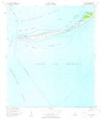
1950 Map of Ship Island
USGS Topo · Published 1963About this map
Ship Island serves as a critical barrier between the Mississippi Sound and the open Gulf of Mexico, as documented in this mid-century survey. The landscape is defined by its maritime infrastructure and shifting sands, notably at West Point and the Northwest Bluff. The map records several significant federal and maritime landmarks, including the defensive works of Old Fort Massachusetts on the western end and the Ship Island Lighthouse nearby.
Find a feature on this map
20 named features on this map. Tap any name to fly to it.
Don’t see what you’re looking for? This feature index may not catch every label — zoom into the map to look around manually.
Map Details
Editions of this 1950 Ship Island Map
3 editions found
Other maps of this area

1893 · Cat Island
USGS Topo · 1:62,500

1950 · Dog Keys Pass
USGS Topo · 1:24,000

1950 · Ship Island
USGS Topo · 1:24,000

1951 · Cat Island
USGS Topo · 1:24,000

1951 · Chandeleur Light
USGS Topo · 1:24,000

1953 · Mobile
USGS Topo · 1:250,000

1954 · Gulfport South
USGS Topo · 1:24,000

1954 · Deer Island
USGS Topo · 1:24,000

1954 · Biloxi
USGS Topo · 1:62,500

1957 · Mobile
USGS Topo · 1:250,000