1945 Map of Shippensburg
USGS Topo · Published 1945About this map
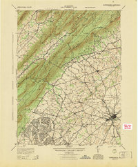
The town of Shippensburg serves as the focal point for this 1945 study, where the plains of the Cumberland Valley meet the formidable ridges of Kittatinny Mountain and Blue Mountain. This era captures a critical moment in modern transportation history with the Pennsylvania Turnpike cutting across the landscape, featuring the Blue Mt Tunnel and Kittatinny Tunnel through the ridge-and-valley terrain. At the Blue Mt Interchange, the new highway age meets the older agrarian patterns of Horse Valley and Amberson Ridge.
Find a feature on this map
94 named features on this map. Tap any name to fly to it.
Don’t see what you’re looking for? This feature index may not catch every label — zoom into the map to look around manually.
Map Details
Editions of this 1945 Shippensburg Map
This is the sole edition of this map. No revisions or reprints were ever made.
Other maps of this area

1900 · Mercersburg
USGS Topo · 1:62,500

1902 · Chambersburg
USGS Topo · 1:62,500

1902 · Mercersburg
USGS Topo · 1:62,500

1909 · Fairfield
USGS Topo · 1:62,500

1919 · Newville
USGS Topo · 1:62,500

1919 · Mattawana
USGS Topo · 1:62,500

1922 · Mt Union
USGS Topo · 1:48,000

1923 · Shippensburg
USGS Topo · 1:62,500

1924 · Mt. Union
USGS Topo · 1:62,500

1930 · Loysville
USGS Topo · 1:62,500