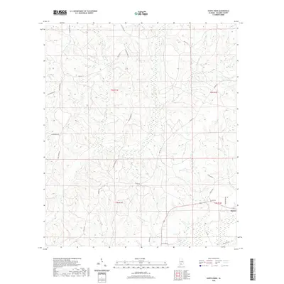
2020 Map of Shipps Creek
USGS Topo · Published 2020About this map
Boykin sits at the intersection of a complex rural road and drainage network in this recent survey of Escambia County. The landscape is defined by its watercourses, including the westward flow of Shipps Cr and the winding Bethel Mill Cr in the south, which drain the timberlands and rural tracts of this region. Family names and local history are reflected in the road network and landmarks, such as Still Cem near the junction of Damascus Rd and Limberpine Rd. The map details numerous access routes through the wooded terrain, from Goulsby Farm Rd to the various branches of Truck Trl 11, highlighting the area's continued reliance on forestry and local transit. This survey records the contemporary boundaries of townships T3N and T2N as they meet across the central plains of the quadrangle.
Find a feature on this map
25 named features on this map. Tap any name to fly to it.
Don’t see what you’re looking for? This feature index may not catch every label — zoom into the map to look around manually.
Map Details
Editions of this 2020 Shipps Creek Map
This is the sole edition of this map. No revisions or reprints were ever made.
Other maps of this area

1953 · Andalusia
USGS Topo · 1:250,000

1957 · Andalusia
USGS Topo · 1:250,000

1959 · Brewton South
USGS Topo · 1:24,000

1960 · Brewton South
USGS Topo · 1:24,000

1960 · Brewton North
USGS Topo · 1:24,000

1971 · Castleberry
USGS Topo · 1:24,000

1982 · Shipps Creek
USGS Topo · 1:24,000
1982 · Roberts
USGS Topo · 1:24,000

1982 · Damascus
USGS Topo · 1:24,000

1982 · Nymph
USGS Topo · 1:24,000