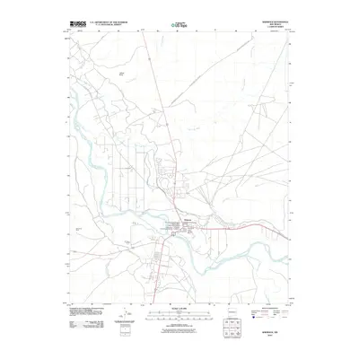
2010 Map of Shiprock
USGS Topo · Published 2010About this map
The San Juan River defines the heart of this landscape, carving through the high desert where the Chaco River and Many Devils Wash join its flow. In 2010, the settlement of Shiprock serves as a vital hub, marked by its Shiprock Post Office and Shiprock Cemetery. The map highlights a concentration of archaeological and cultural preservation, specifically the Hogback Archaeological District and the Mitten Rock Archaeological District. The San Juan River Bridge Historic Site stands as a notable engineering landmark near the town center. Industrial activity is evident through various operations like the Blanchard Mine to the west and the Shiprock Pit and Enos Johnson Mine to the east. Navigating the terrain are several indigenous transport routes, including Indian Service Route 5031 and Indian Service Route 36, while intricate irrigation systems like Ditch Number Nine and Cudei Ditch line the river valley.
Find a feature on this map
27 named features on this map. Tap any name to fly to it.
Don’t see what you’re looking for? This feature index may not catch every label — zoom into the map to look around manually.
Map Details
Editions of this 2010 Shiprock Map
This is the sole edition of this map. No revisions or reprints were ever made.
Other maps of this area

1889 · Chaco
USGS Topo · 1:250,000

1892 · Chaco
USGS Topo · 1:250,000

1927 · Sulphur Spring
USGS Topo · 1:96,000

1928 · Kirtland
USGS Topo · 1:125,000

1932 · Kirtland
USGS Topo · 1:125,000

1934 · Ship Rock
USGS Topo · 1:62,500

1934 · Chimney Rock
USGS Topo · 1:62,500

1934 · Rattlesnake
USGS Topo · 1:62,500

1936 · Chimney Rock
USGS Topo · 1:62,500

1937 · Ship Rock
USGS Topo · 1:62,500