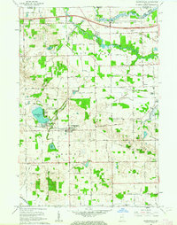
1961 Map of Shipshewana
USGS Topo · Published 1963About this map
Shipshewana serves as the focal point of this Northern Indiana landscape, situated just south of the Indiana Toll Road in LaGrange County. The early 1960s terrain is defined by its glacial hydrology, with Shipshewana Lake featuring the United Brethren Camp and Beatys Beach along its eastern shore. Agricultural life is evidenced by a dense network of country schools and family cemeteries, including the Newberry-Van Buren Twp Sch, Pashan Sch, and Miller Cem.
Find a feature on this map
42 named features on this map. Tap any name to fly to it.
Don’t see what you’re looking for? This feature index may not catch every label — zoom into the map to look around manually.
Map Details
Editions of this 1961 Shipshewana Map
This is the sole edition of this map. No revisions or reprints were ever made.
Other maps of this area

1914 · Three Rivers
USGS Topo · 1:62,500

1916 · Three Rivers
USGS Topo · 1:62,500

1943 · Three Rivers
USGS Topo · 1:62,500

1947 · Lagrange
USGS Topo · 1:24,000

1947 · Oliver Lake
USGS Topo · 1:24,000

1953 · Fort Wayne
USGS Topo · 1:250,000

1956 · Fort Wayne
USGS Topo · 1:250,000

1959 · Topeka
USGS Topo · 1:24,000
1959 · Oliver Lake
USGS Topo · 1:24,000

1959 · Millersburg
USGS Topo · 1:24,000