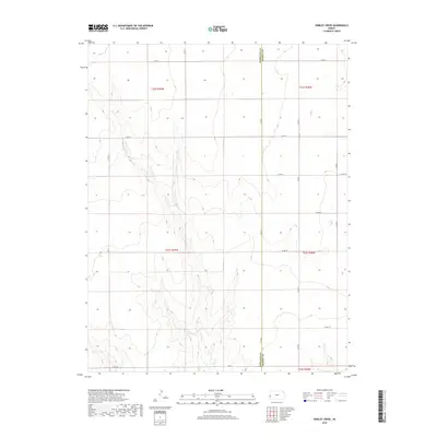
2018 Map of Shirley Creek
USGS Topo · Published 2018About this map
The border between Hamilton Co and Kearny Co defines the central axis of this landscape, reflecting the rigid Public Land Survey System that carved out this portion of western Kansas. The terrain is characterized by a network of drainage patterns and dry creek beds that dissect the high plains, illustrating the subtle but complex topography of the region. A strict orthogonal grid of section lines and county roads, such as Co Rd 11 and Co Rd B, structures the land for agricultural use. The map highlights the intersection of modern infrastructure and traditional township boundaries, including t22s r39w and t23s r38w. This layout demonstrates the enduring influence of 19th-century land division on 21st-century rural logistics, where access is maintained via a systematic naming convention of lettered and numbered routes like Co Rd A and Co Rd 16.
Find a feature on this map
19 named features on this map. Tap any name to fly to it.
Don’t see what you’re looking for? This feature index may not catch every label — zoom into the map to look around manually.
Map Details
Editions of this 2018 Shirley Creek Map
This is the sole edition of this map. No revisions or reprints were ever made.
Other maps of this area

1891 · Larned
USGS Topo · 1:125,000

1900 · Syracuse
USGS Topo · 1:125,000

1900 · Lakin
USGS Topo · 1:125,000

1920 · Syracuse
USGS Topo · 1:125,000

1955 · Dodge City
USGS Topo · 1:250,000

1955 · Scott City
USGS Topo · 1:250,000

1958 · Dodge City
USGS Topo · 1:250,000

1958 · Scott City
USGS Topo · 1:250,000

1959 · Dodge City
USGS Topo · 1:250,000

1965 · Leoti 3 NW
USGS Topo · 1:24,000