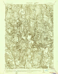
1935 Map of Shirley
USGS Topo · Published 1935About this map
The Nashua River and Catacoonamug Brook define the industrial and natural character of this 1935 landscape where the Middlesex Co Worcester Co boundary line bisects the territory. The rail-centered development of Shirley and North Leominster is evident along the Boston and Maine RR, which provided a critical connection for local mills and residents. The northern reaches of Fort Devens appear at the eastern edge, while the sprawling campus of the Shirley Massachusetts Industrial School For Boys occupies a significant portion of the town's southern landscape. The terrain is marked by numerous water bodies like Shirley Reservoir, Massapoag Pond, and Fort Pond, which likely supported local agricultural and industrial needs during the mid-1930s. Genealogists may find interest in the precise location of St Cecelia Cemetery and the various hills like Prospect Hill and Treasure Hill that shaped the rural character outside the village centers.
Find a feature on this map
35 named features on this map. Tap any name to fly to it.
Don’t see what you’re looking for? This feature index may not catch every label — zoom into the map to look around manually.
Map Details
Editions of this 1935 Shirley Map
3 editions found
Other maps of this area

1885 · Worcester
USGS Topo · 1:62,500

1886 · Worcester
USGS Topo · 1:62,500

1887 · Marlboro
USGS Topo · 1:62,500

1887 · Fitchburg
USGS Topo · 1:62,500

1889 · Marlboro
USGS Topo · 1:62,500

1889 · Fitchburg
USGS Topo · 1:62,500

1892 · Worcester
USGS Topo · 1:62,500

1893 · Fitchburg
USGS Topo · 1:62,500

1893 · Groton
USGS Topo · 1:62,500

1896 · Marlboro
USGS Topo · 1:62,500