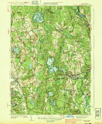
1939 Map of Shirley
USGS Topo · Published 1939About this map
The boundary between Worcester and Middlesex counties serves as a central spine for this 1930s landscape, where the Nashua River and Squannacook River frame a region of active industry and institutional presence. Settlement is concentrated along the Boston and Maine Railroad, which connects the industrial hub of Leominster and its northern counterpart North Leominster to Shirley and West Groton. The map reveals a highly structured environment, featuring the Industrial School and a Rifle Range in the south, alongside established community centers like Shirley Center.
Find a feature on this map
112 named features on this map. Tap any name to fly to it.
Don’t see what you’re looking for? This feature index may not catch every label — zoom into the map to look around manually.
Map Details
Editions of this 1939 Shirley Map
3 editions found
Other maps of this area

1885 · Worcester
USGS Topo · 1:62,500

1886 · Worcester
USGS Topo · 1:62,500

1887 · Marlboro
USGS Topo · 1:62,500

1887 · Fitchburg
USGS Topo · 1:62,500

1889 · Marlboro
USGS Topo · 1:62,500

1889 · Fitchburg
USGS Topo · 1:62,500

1892 · Worcester
USGS Topo · 1:62,500

1893 · Fitchburg
USGS Topo · 1:62,500

1893 · Groton
USGS Topo · 1:62,500

1896 · Marlboro
USGS Topo · 1:62,500