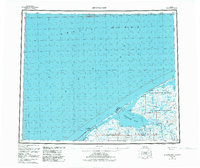
1950 Map of Shishmaref
USGS Topo · Published 1984About this map
Shishmaref sits on Sarichef Island, acting as a remote threshold between the Chukchi Sea and the expansive Shishmaref Inlet. This mid-century survey captures the northern reach of the Seward Peninsula just as the Arctic Circle crosses the terrain. The landscape is defined by the complex hydrology of the Arctic Lagoon and the winding paths of the Serpentine River and Cowpack River. Much of the eastern portion is dedicated to the Bering Land Bridge National Preserve, reflecting the area's significance as a prehistoric migration corridor. Human infrastructure is sparse but critical, evidenced by the Landing Strip and a Winter Trail that provides a terrestrial link across the frozen expanses. Coastal landmarks like Cape Lowenstern look out toward the Bering Strait, marking the geographical boundary between the Americas and Asia.
Find a feature on this map
21 named features on this map. Tap any name to fly to it.
Don’t see what you’re looking for? This feature index may not catch every label — zoom into the map to look around manually.
Map Details
Editions of this 1950 Shishmaref Map
5 editions found
Other maps of this area

1950 · Kotzebue C-6
USGS Topo · 1:63,360

1950 · Bendeleben D-6
USGS Topo · 1:63,360

1950 · Teller
USGS Topo · 1:250,000

1950 · Bendeleben
USGS Topo · 1:250,000

1950 · Shishmaref
USGS Topo · 1:250,000

1950 · Shishmaref A-1
USGS Topo · 1:63,360

1950 · Kotzebue A-6
USGS Topo · 1:63,360

1950 · Teller D-2
USGS Topo · 1:63,360

1950 · Teller D-3
USGS Topo · 1:63,360

1950 · Teller D-5
USGS Topo · 1:63,360