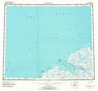
1950 Map of Shishmaref
USGS Topo · Published 1971About this map
Arctic Circle geography defines this 1950s-era study of the northern coast of the Seward Peninsula, where the Chukchi Sea meets the Arctic Ocean. The settlement of Shishmaref sits on Sarichef Island, acting as a gateway to the massive Shishmaref Inlet and the nearby Arctic Lagoon. This environment is characterized by complex hydrography, including the Serpentine River and Kugrupuk River, which drain into the tidal inlets.
Find a feature on this map
25 named features on this map. Tap any name to fly to it.
Don’t see what you’re looking for? This feature index may not catch every label — zoom into the map to look around manually.
Map Details
Editions of this 1950 Shishmaref Map
5 editions found
Other maps of this area

1950 · Kotzebue C-6
USGS Topo · 1:63,360

1950 · Bendeleben D-6
USGS Topo · 1:63,360

1950 · Teller
USGS Topo · 1:250,000

1950 · Bendeleben
USGS Topo · 1:250,000

1950 · Shishmaref
USGS Topo · 1:250,000

1950 · Shishmaref A-1
USGS Topo · 1:63,360

1950 · Kotzebue A-6
USGS Topo · 1:63,360

1950 · Teller D-2
USGS Topo · 1:63,360

1950 · Teller D-3
USGS Topo · 1:63,360

1950 · Teller D-5
USGS Topo · 1:63,360