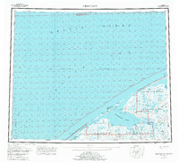
1950 Map of Shishmaref
USGS Topo · Published 1980About this map
Sarichef Island stands as a primary landform at the edge of the Chukchi Sea, separating the open ocean from the sheltered waters of Shishmaref Inlet and Arctic Lagoon. This 1950s survey, compiled from early aerial photography, illustrates the remote coastal landscape of the Seward Peninsula before its inclusion within the Bering Land Bridge National Monument. The map detail highlights the sparse infrastructure of the era, marked by a seasonal Winter Trail and a solitary Shelter Cabin positioned along the coast. Waterways like the Serpentine River and Cowpack River snake through the tundra toward the coast, while the Arctic Circle line crosses the northern reaches of the sheet, underscoring the extreme latitude of this coastal environment.
Find a feature on this map
24 named features on this map. Tap any name to fly to it.
Don’t see what you’re looking for? This feature index may not catch every label — zoom into the map to look around manually.
Map Details
Editions of this 1950 Shishmaref Map
5 editions found
Other maps of this area

1950 · Kotzebue C-6
USGS Topo · 1:63,360

1950 · Bendeleben D-6
USGS Topo · 1:63,360

1950 · Teller
USGS Topo · 1:250,000

1950 · Bendeleben
USGS Topo · 1:250,000

1950 · Shishmaref
USGS Topo · 1:250,000

1950 · Shishmaref A-1
USGS Topo · 1:63,360

1950 · Kotzebue A-6
USGS Topo · 1:63,360

1950 · Teller D-2
USGS Topo · 1:63,360

1950 · Teller D-3
USGS Topo · 1:63,360

1950 · Teller D-5
USGS Topo · 1:63,360