
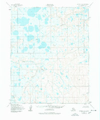
1950 Map of Kotzebue A-6
USGS Topo · Published 1957About this map
Nugnugaluktuk River meanders across this Seward Peninsula landscape, which was documented through aerial photography just after the mid-century. The terrain is characterized by a high density of thaw lakes and ponds in the north, giving way to the braided channels of the North Fork Serpentine River and its tributary, Buck Creek. This 1950s survey, mapped by the Army Map Service, captures a wilderness prior to significant modern encroachment, where topographic relief is defined by survey markers such as Stone VABM 179 and Lane VABM 988. The Lane River drains the southeastern corner of the quadrangle, illustrating the complex drainage patterns of this subarctic environment before contemporary shifts in permafrost and hydrology.
Find a feature on this map
6 named features on this map. Tap any name to fly to it.
Don’t see what you’re looking for? This feature index may not catch every label — zoom into the map to look around manually.
Map Details
Editions of this 1950 Kotzebue A-6 Map
2 editions found
Other maps of this area

1950 · Bendeleben D-6
USGS Topo · 1:63,360

1950 · Teller
USGS Topo · 1:250,000

1950 · Bendeleben D-5
USGS Topo · 1:63,360

1950 · Bendeleben
USGS Topo · 1:250,000

1950 · Shishmaref
USGS Topo · 1:250,000

1950 · Shishmaref A-1
USGS Topo · 1:63,360

1950 · Shishmaref B-1
USGS Topo · 1:63,360

1950 · Kotzebue B-5
USGS Topo · 1:63,360

1950 · Kotzebue B-6
USGS Topo · 1:63,360

1950 · Kotzebue A-5
USGS Topo · 1:63,360