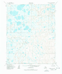
1950 Map of Kotzebue A-6
USGS Topo · Published 1978About this map
The Serpentine River flows through an intricate network of waterways and thousands of small tundra ponds in this 1950s-era survey of the Seward Peninsula. The landscape is defined by the convergence of the North Fork Serpentine River and Rock Creek, which snake through a flat, water-saturated expanse before the terrain rises toward the east. This area, captured through 1949 and 1950 photogrammetric methods by the Army Map Service, shows a wilderness primarily shaped by natural drainage patterns rather than human infrastructure. Prominent survey points like VABM Stone and VABM Lane provide the only named terrestrial landmarks, while the Nugnugaluktuk River and Lane River drain the northern and eastern reaches. The absence of roads or trails on this sheet emphasizes the isolation of the region during the mid-twentieth century.
Find a feature on this map
7 named features on this map. Tap any name to fly to it.
Don’t see what you’re looking for? This feature index may not catch every label — zoom into the map to look around manually.
Map Details
Editions of this 1950 Kotzebue A-6 Map
2 editions found
Other maps of this area

1950 · Bendeleben D-6
USGS Topo · 1:63,360

1950 · Teller
USGS Topo · 1:250,000

1950 · Bendeleben D-5
USGS Topo · 1:63,360

1950 · Bendeleben
USGS Topo · 1:250,000

1950 · Shishmaref
USGS Topo · 1:250,000

1950 · Shishmaref A-1
USGS Topo · 1:63,360

1950 · Kotzebue A-6
USGS Topo · 1:63,360

1950 · Shishmaref B-1
USGS Topo · 1:63,360

1950 · Kotzebue B-5
USGS Topo · 1:63,360

1950 · Kotzebue B-6
USGS Topo · 1:63,360