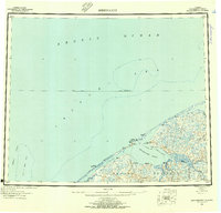
1950 Map of Shishmaref
USGS Topo · Published 1956About this map
Sarichef Island sits at the edge of the Chukchi Sea, serving as the site for the settlement of Shishmaref. This mid-century survey illustrates the delicate geography of the northern Seward Peninsula, where the land is fragmented into a complex system of coastal waters including Arctic Lagoon and Shishmaref Inlet. The map documents a sparse but vital network of infrastructure, notably the Winter Trail and the Sinrazat Shelter Cabin, which represent the primary means of travel and safety across this subarctic landscape.
Find a feature on this map
21 named features on this map. Tap any name to fly to it.
Don’t see what you’re looking for? This feature index may not catch every label — zoom into the map to look around manually.
Map Details
Editions of this 1950 Shishmaref Map
5 editions found
Other maps of this area

1950 · Kotzebue C-6
USGS Topo · 1:63,360

1950 · Bendeleben D-6
USGS Topo · 1:63,360

1950 · Teller
USGS Topo · 1:250,000

1950 · Bendeleben
USGS Topo · 1:250,000

1950 · Shishmaref
USGS Topo · 1:250,000

1950 · Shishmaref A-1
USGS Topo · 1:63,360

1950 · Kotzebue A-6
USGS Topo · 1:63,360

1950 · Teller D-2
USGS Topo · 1:63,360

1950 · Teller D-3
USGS Topo · 1:63,360

1950 · Teller D-5
USGS Topo · 1:63,360