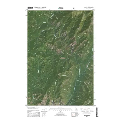
2017 Map of Shissler Peak
USGS Topo · Published 2017About this map
Nez Perce National Forest dominates this landscape in northern Idaho, where the complex drainage systems of North Fork Moose Creek and the East Fork Moose Creek converge. The topography is defined by high-elevation points such as Shissler Peak and Goat Mtn, while the Moose Creek/USFS Airport in the south provides a critical point of access for fire management and backcountry transit in the Selway-Bitterroot area. Named ridges and peaks like Log Ridge, Shasta Point, and Cone Peak provide a framework for the dense network of tributaries including Whistling Pig Cr, Rhoda Cr, and Sixty-two Cr. This area is characterized by its hydrological complexity, with numerous small creeks such as Barren Cr, Vista Cr, and Divide Cr feeding into the larger Moose Creek basin.
Find a feature on this map
36 named features on this map. Tap any name to fly to it.
Don’t see what you’re looking for? This feature index may not catch every label — zoom into the map to look around manually.
Map Details
Editions of this 2017 Shissler Peak Map
This is the sole edition of this map. No revisions or reprints were ever made.
Other maps of this area

1911 · Lolo
USGS Topo · 1:250,000

1913 · Lolo
USGS Topo · 1:250,000

1956 · Hamilton
USGS Topo · 1:250,000

1959 · Hamilton
USGS Topo · 1:250,000

1960 · Hamilton
USGS Topo · 1:250,000

1964 · Hamilton
USGS Topo · 1:250,000

1966 · Mc Connell Mtn
USGS Topo · 1:24,000

1966 · Moose Ridge
USGS Topo · 1:24,000

1966 · Dog Creek
USGS Topo · 1:24,000
1966 · Big Rock Mtn
USGS Topo · 1:24,000