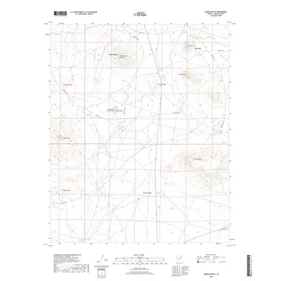
2018 Map of Shonto Butte
USGS Topo · Published 2018About this map
Seba Dalkai and Tees Toh anchor this high-desert landscape within the Fort Defiance Agency, where the terrain is defined by a series of prominent mesas and buttes. The topography is dominated by formations such as Bad Medicine Butte, Saddle Butte, and Bobcat Butte, which rise above the ephemeral drainages of Fees-Toh-Wash and Tees Toh Wash. This 2018 survey reveals a sparse but established road network consisting of numerous Indian Routes, including Indian Rte 60 and Indian Rte 9845, which connect isolated features like the Twentieth Street School. Evidence of water sources in this arid region is visible through labels for Coyote Springs, Shonto Spring, and Chandler Springs, providing critical landmarks for understanding the historical settlement patterns and land use in this part of Navajo County.
Find a feature on this map
25 named features on this map. Tap any name to fly to it.
Don’t see what you’re looking for? This feature index may not catch every label — zoom into the map to look around manually.
Map Details
Editions of this 2018 Shonto Butte Map
This is the sole edition of this map. No revisions or reprints were ever made.
Other maps of this area

1883 · Tusayan
USGS Topo · 1:250,000

1886 · Tusayan
USGS Topo · 1:250,000

1947 · Flagstaff
USGS Topo · 1:250,000

1954 · Flagstaff
USGS Topo · 1:250,000

1958 · Flagstaff
USGS Topo · 1:250,000

1960 · Flagstaff
USGS Topo · 1:250,000

1962 · Flagstaff
USGS Topo · 1:250,000

1966 · Egloffstein Butte
USGS Topo · 1:62,500

1966 · Tovar Mesa
USGS Topo · 1:62,500
1967 · Dilkon
USGS Topo · 1:24,000
Featured Places
- Fort Defiance Agency
- Seba Dalkai, Fort Defiance Agency
- Tees Toh, Fort Defiance Agency
- Navajo County, AZ
- United States