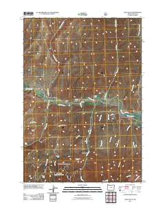
2011 Map of Shop Gulch
USGS Topo · Published 2011About this map
The John Day River carves through the heart of this landscape, serving as a primary corridor for travel and settlement in central Oregon. Near its banks, Moores Crossing marks a key historical transit point, while the presence of the Glascock Ranch highlights the region's enduring ranching heritage. The terrain is defined by a series of steep drainages, including Shop Gulch and Spring Gulch, which feed into the river valley. To the south, the topography rises toward Coyote Butte and Horseshoe Butte, while the scarred landscape of the Widows Creek Burn provides evidence of more recent environmental shifts. The intricate network of local routes like Fields Creek Rd and Widows Creek South Rd follows the natural contours of the creeks, illustrating how the geography of Grant County dictates the path of human infrastructure.
Find a feature on this map
34 named features on this map. Tap any name to fly to it.
Don’t see what you’re looking for? This feature index may not catch every label — zoom into the map to look around manually.
Map Details
Editions of this 2011 Shop Gulch Map
This is the sole edition of this map. No revisions or reprints were ever made.
Other maps of this area

1940 · Mount Vernon
USGS Topo · 1:62,500

1940 · Aldrich Mtn.
USGS Topo · 1:62,500

1943 · Aldrich Mtn.
USGS Topo · 1:62,500

1943 · Mount Vernon
USGS Topo · 1:62,500

1949 · Long Creek
USGS Topo · 1:62,500

1951 · Long Creek
USGS Topo · 1:62,500

1951 · Courtrock
USGS Topo · 1:62,500

1955 · Canyon City
USGS Topo · 1:250,000

1959 · Canyon City
USGS Topo · 1:250,000

1972 · Big Weasel Sprs
USGS Topo · 1:24,000