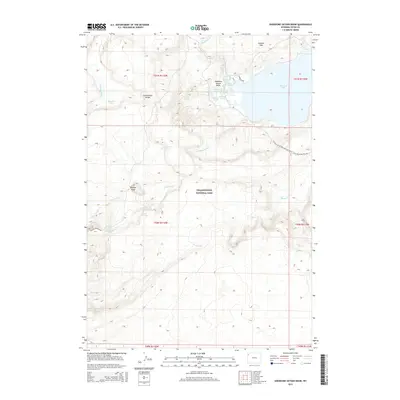
2015 Map of Shoshone Geyser Basin
USGS Topo · Published 2015About this map
Shoshone Geyser Basin serves as a focal point for this wilderness survey, highlighting the active geothermal features within Yellowstone National Park. The map documents a complex hydrological network where the Firehole River originates near Madison Lake, while the Continental Divide winds through the high country, separating the drainage of Shoshone Lake from the westward-flowing waters. Researchers can identify specific thermal vents including Little Giant Geyser, Shield Geyser, and the Orion Group. The terrain is further defined by the Cement Hills and Douglas Knob, with backcountry access marked by the Continental Divide National Scenic Trail and the Bechler River Trail. This detailed recording of springs and geysers like Washtub Spring and Boiling Spring provides an essential record of the park's hydrothermal activity in the early 21st century.
Find a feature on this map
33 named features on this map. Tap any name to fly to it.
Don’t see what you’re looking for? This feature index may not catch every label — zoom into the map to look around manually.
Map Details
Editions of this 2015 Shoshone Geyser Basin Map
This is the sole edition of this map. No revisions or reprints were ever made.
Other maps of this area

1886 · Shoshone
USGS Topo · 1:125,000

1888 · Shoshone
USGS Topo · 1:125,000

1895 · Shoshone
USGS Topo · 1:125,000

1901 · Shoshone
USGS Topo · 1:125,000

1908 · Shoshone
USGS Topo · 1:125,000

1911 · Shoshone
USGS Topo · 1:125,000

1955 · Ashton
USGS Topo · 1:250,000
1956 · West Thumb
USGS Topo · 1:62,500

1956 · Old Faithful
USGS Topo · 1:62,500

1956 · Grassy Lake Reservoir
USGS Topo · 1:62,500