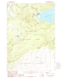
1986 Map of Shoshone Geyser Basin
USGS Topo · Published 1986About this map
The Continental Divide winds through this high-altitude landscape of southwestern Yellowstone National Park, marking the separation of the continent's major watersheds. At the heart of the terrain lies the Shoshone Geyser Basin, a dense hydrothermal area located at the western edge of Shoshone Lake. This geothermal hub is meticulously documented with individual vents and features such as Little Giant Geyser, Union Geyser, and the Boiling Spring. To the south, the expansive Pitchstone Plateau dominates the geography, a massive volcanic feature that feeds numerous drainage systems, including the Ferris Fork and Gregg Fork. The map also captures the headwaters of the Firehole River as it emerges from Madison Lake, tracing the early course of one of the park's most famous waterways through isolated backcountry.
Find a feature on this map
26 named features on this map. Tap any name to fly to it.
Don’t see what you’re looking for? This feature index may not catch every label — zoom into the map to look around manually.
Map Details
Editions of this 1986 Shoshone Geyser Basin Map
2 editions found
Other maps of this area

1886 · Shoshone
USGS Topo · 1:125,000

1888 · Shoshone
USGS Topo · 1:125,000

1895 · Shoshone
USGS Topo · 1:125,000

1901 · Shoshone
USGS Topo · 1:125,000

1908 · Shoshone
USGS Topo · 1:125,000

1911 · Shoshone
USGS Topo · 1:125,000

1955 · Ashton
USGS Topo · 1:250,000
1956 · West Thumb
USGS Topo · 1:62,500

1956 · Old Faithful
USGS Topo · 1:62,500

1956 · Grassy Lake Reservoir
USGS Topo · 1:62,500