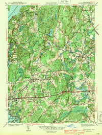
1943 Map of Shrewsbury
USGS Topo · Published 1943About this map
The eastern edges of the Wachusett Reservoir define the northwestern corner of this 1941 survey, showing a landscape shaped by both water engineering and institutional development. The area is a nexus of major transit and civic facilities, notably featuring the Masonic Hospital and the extensive grounds of the Worcester Hospital. These large parcels sit alongside the developing residential centers of Shrewsbury and Northboro, where a dense network of local roads like Ball Hill Road and Main St connects scattered neighborhoods to the vital rail corridors of the New York New Haven and Hartford RR and the Boston and Maine RR.
Find a feature on this map
94 named features on this map. Tap any name to fly to it.
Don’t see what you’re looking for? This feature index may not catch every label — zoom into the map to look around manually.
Map Details
Editions of this 1943 Shrewsbury Map
3 editions found
Other maps of this area

1885 · Worcester
USGS Topo · 1:62,500

1886 · Worcester
USGS Topo · 1:62,500

1886 · Blackstone
USGS Topo · 1:62,500

1887 · Marlboro
USGS Topo · 1:62,500

1889 · Marlboro
USGS Topo · 1:62,500

1889 · Blackstone
USGS Topo · 1:62,500

1889 · Webster
USGS Topo · 1:62,500

1892 · Webster
USGS Topo · 1:62,500

1892 · Worcester
USGS Topo · 1:62,500

1893 · Blackstone
USGS Topo · 1:62,500