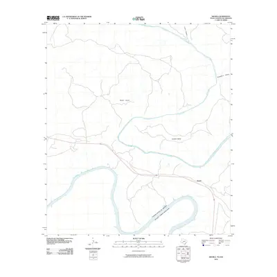
2010 Map of Shumla
USGS Topo · Published 2010About this map
The Rio Grande and the Pecos River converge in this borderland landscape, where the international boundary separates the United States of America and Estados Unidos Mexicanos. The terrain is defined by deep incisions through the desert floor, including Painted Canyon, Lewis Canyon, and Shackelford Canyon, which drain toward the river systems. The rise of the Amistad Reservoir has altered the lower reaches of these canyons, creating fingers of water that reach into the arid interior. Near the center of the sheet, the railway-aligned settlement of Shumla sits above the massive loop of the Shumla Bend. This area reflects the logistical challenges of West Texas travel, where infrastructure must navigate the high bluffs and winding watercourses of the Val Verde county region.
Find a feature on this map
9 named features on this map. Tap any name to fly to it.
Don’t see what you’re looking for? This feature index may not catch every label — zoom into the map to look around manually.
Map Details
Editions of this 2010 Shumla Map
This is the sole edition of this map. No revisions or reprints were ever made.
Other maps of this area

1943 · Langtry
USGS Topo · 1:62,500

1943 · Shumla
USGS Topo · 1:62,500

1944 · Mouth Of Pecos
USGS Topo · 1:62,500

1958 · Del Rio
USGS Topo · 1:250,000

1964 · Del Rio
USGS Topo · 1:250,000
1972 · Zuberbueler Bend NW
USGS Topo · 1:24,000

1972 · Seminole Canyon
USGS Topo · 1:24,000

1973 · Langtry
USGS Topo · 1:24,000
1973 · Still Canyon
USGS Topo · 1:24,000
1973 · Shumla
USGS Topo · 1:24,000