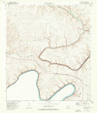
1973 Map of Shumla
USGS Topo · Published 1976About this map
The confluence of the Rio Grande and Pecos River dominates this southwestern border landscape during the mid-1970s. This period reflects a transformed environment where the waters of the Amistad Reservoir have filled the deep canyons of Val Verde County, creating a massive water body that defines the United States Mexico border and the National Recreation Area. The Southern Pacific railroad cuts across the arid terrain, passing through the small settlement of Shumla and crossing the high bridge over the Pecos. Grounded in the rugged geography of the Trans-Pecos, the map details a network of canyons including Painted Canyon, Lewis Canyon, and Shackelford Can. Local infrastructure is sparse, characterized by a remote Landing Strip, a Gaging Sta on the river, and small industrial sites like a Quarry and Gravel Pit positioned near the rail line.
Find a feature on this map
17 named features on this map. Tap any name to fly to it.
Don’t see what you’re looking for? This feature index may not catch every label — zoom into the map to look around manually.
Map Details
Editions of this 1973 Shumla Map
This is the sole edition of this map. No revisions or reprints were ever made.
Other maps of this area

1943 · Langtry
USGS Topo · 1:62,500

1943 · Shumla
USGS Topo · 1:62,500

1944 · Mouth Of Pecos
USGS Topo · 1:62,500

1958 · Del Rio
USGS Topo · 1:250,000

1964 · Del Rio
USGS Topo · 1:250,000
1972 · Zuberbueler Bend NW
USGS Topo · 1:24,000

1972 · Seminole Canyon
USGS Topo · 1:24,000

1973 · Langtry
USGS Topo · 1:24,000
1973 · Still Canyon
USGS Topo · 1:24,000
1973 · Harkell Canyon
USGS Topo · 1:24,000