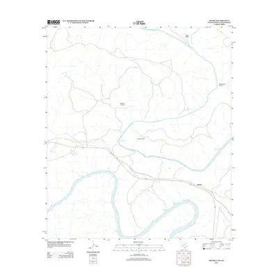
2013 Map of Shumla
USGS Topo · Published 2013About this map
The Rio Grande and the Pecos River converge in this high-desert landscape, creating a complex network of deep drainages and limestone breaks. The small settlement of Shumla sits north of the international boundary, positioned near the railroad corridor that traverses this arid terrain. The mapping reveals the reach of the Amistad Reservoir, where rising waters back into the lower canyons of the Pecos and the sweeping curve of Shumla Bend. This topography is defined by significant vertical relief, where erosion has carved prominent features such as Lewis Canyon, Shackelford Canyon, and the appropriately named Painted Canyon. The intersection of these major watercourses and the dry canyon systems illustrates the stark environmental transition from river-level riparian zones to the surrounding desert uplands.
Find a feature on this map
8 named features on this map. Tap any name to fly to it.
Don’t see what you’re looking for? This feature index may not catch every label — zoom into the map to look around manually.
Map Details
Editions of this 2013 Shumla Map
This is the sole edition of this map. No revisions or reprints were ever made.
Other maps of this area

1943 · Langtry
USGS Topo · 1:62,500

1943 · Shumla
USGS Topo · 1:62,500

1944 · Mouth Of Pecos
USGS Topo · 1:62,500

1958 · Del Rio
USGS Topo · 1:250,000

1964 · Del Rio
USGS Topo · 1:250,000
1972 · Zuberbueler Bend NW
USGS Topo · 1:24,000

1972 · Seminole Canyon
USGS Topo · 1:24,000

1973 · Langtry
USGS Topo · 1:24,000
1973 · Still Canyon
USGS Topo · 1:24,000
1973 · Shumla
USGS Topo · 1:24,000