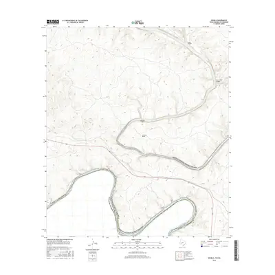
2016 Map of Shumla
USGS Topo · Published 2016About this map
The Rio Grande and the Pecos River converge in this borderlands landscape, creating a complex series of deep drainages and canyon systems. Centered on the Amistad National Recreation Area, the topography is dominated by the winding course of the Amistad Reservoir as it fills the carved basins of the primary rivers. The small settlement of Shumla sits north of a large meander known as Shumla Bend, providing a point of reference along the transit corridor of Highway 90. Dramatic relief is evident in the numerous named cuts through the limestone, including Lewis Canyon, Shackelford Canyon, and Painted Canyon. These features define the international boundary between the United States and Mexico, where the river serves as both a physical barrier and a shared geographic center for the region.
Find a feature on this map
12 named features on this map. Tap any name to fly to it.
Don’t see what you’re looking for? This feature index may not catch every label — zoom into the map to look around manually.
Map Details
Editions of this 2016 Shumla Map
This is the sole edition of this map. No revisions or reprints were ever made.
Other maps of this area

1943 · Langtry
USGS Topo · 1:62,500

1943 · Shumla
USGS Topo · 1:62,500

1944 · Mouth Of Pecos
USGS Topo · 1:62,500

1958 · Del Rio
USGS Topo · 1:250,000

1964 · Del Rio
USGS Topo · 1:250,000
1972 · Zuberbueler Bend NW
USGS Topo · 1:24,000

1972 · Seminole Canyon
USGS Topo · 1:24,000

1973 · Langtry
USGS Topo · 1:24,000
1973 · Still Canyon
USGS Topo · 1:24,000
1973 · Shumla
USGS Topo · 1:24,000