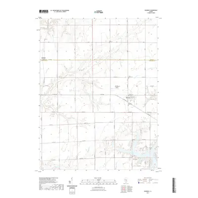
2021 Map of Shumway
USGS Topo · Published 2021About this map
Shumway sits at the intersection of prairie agriculture and the dendritic drainage systems of central Illinois, where the landscape transitions into the southern reaches of the state. This modern survey illustrates a community anchored by its spiritual and civic heritage, evidenced by the numerous local burial grounds including Shumway Cem, Saint Marys Catholic Cem, and Trinity Lutheran Cem. To the south, the irregular shoreline of Lake Sara introduces a significant recreational and residential element to the terrain, with developments like Twin Oaks Dr and S Circle Dr bordering the water. The northern portion of the map is defined by the Shelby and Effingham county line, where small settlements like Holland and infrastructure such as the Shumway International Airport serve the rural population. Numerous tributaries including Wolf Creek and Shoal Creek carve through the agricultural blocks, shaping the placement of the region’s secondary roads and homesteads.
Find a feature on this map
48 named features on this map. Tap any name to fly to it.
Don’t see what you’re looking for? This feature index may not catch every label — zoom into the map to look around manually.
Map Details
Editions of this 2021 Shumway Map
This is the sole edition of this map. No revisions or reprints were ever made.
Other maps of this area

1941 · St. Elmo
USGS Topo · 1:62,500

1942 · Shelbyville
USGS Topo · 1:62,500

1945 · St. Elmo
USGS Topo · 1:62,500

1946 · Shelbyville
USGS Topo · 1:62,500

1947 · Stewardson
USGS Topo · 1:62,500

1949 · Stewardson
USGS Topo · 1:62,500

1950 · Effingham
USGS Topo · 1:62,500

1951 · Effingham
USGS Topo · 1:62,500

1958 · Decatur
USGS Topo · 1:250,000

1961 · Decatur
USGS Topo · 1:250,000