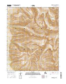
2016 Map of Shungnak A-1 NE
USGS Topo · Published 2016About this map
The Zane Hills dominate this portion of the Alaskan interior, presenting a high-elevation landscape defined by significant relief and glacial drainage patterns. Rising prominently in the central region is Cone Mtn, a notable landmark that anchors the surrounding topography. The drainage network is characterized by the southward flow of the Dakli River and the eastern waters of Clear Cr and Caribou Cr. This 2016 survey illustrates the undeveloped character of the Brooks Range foothills, where the primary organizational structure remains the Public Land Survey System. The map provides precise contour data for the steep slopes and high ridges that characterize this remote territory, offering an essential record of the natural terrain before any potential future shifts in land use or geological changes in the region.
Find a feature on this map
12 named features on this map. Tap any name to fly to it.
Don’t see what you’re looking for? This feature index may not catch every label — zoom into the map to look around manually.
Map Details
Editions of this 2016 Shungnak A-1 NE Map
This is the sole edition of this map. No revisions or reprints were ever made.
Other maps of this area

1951 · Shungnak
USGS Topo · 1:250,000

1951 · Hughes
USGS Topo · 1:250,000

1955 · Shungnak
USGS Topo · 1:250,000

1956 · Hughes
USGS Topo · 1:250,000

1964 · Shungnak
USGS Topo · 1:250,000

1964 · Hughes
USGS Topo · 1:250,000

1965 · Hughes
USGS Topo · 1:250,000
1985 · Shungnak B-1
USGS Topo · 1:63,360
1985 · Shungnak A-1
USGS Topo · 1:63,360
1986 · Hughes A-6
USGS Topo · 1:63,360