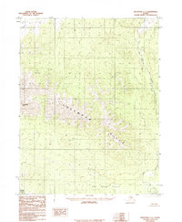
1985 Map of Shungnak C-1
USGS Topo · Published 1985About this map
Lockwood Hills dominate the central geography of this 1985 provisional study in the Northwest Arctic. The terrain is defined by the significant elevation of Angutikada Peak to the west and the expansive lowlands of the Pah River Flats to the south. This environment is largely characterized by its lack of roads and permanent human infrastructure, emphasizing a wilderness preserved within the Selawik NWR boundary. The Pah River winds through the eastern and southern portions of the quadrangle, serving as the primary drainage and a natural corridor through the foothills. This survey captures a moment of transition for the region, reflecting the land use and preservation status established under the Alaska National Interest Lands Conservation Act.
Find a feature on this map
5 named features on this map. Tap any name to fly to it.
Don’t see what you’re looking for? This feature index may not catch every label — zoom into the map to look around manually.
Map Details
Editions of this 1985 Shungnak C-1 Map
This is the sole edition of this map. No revisions or reprints were ever made.
Other maps of this area

1951 · Shungnak
USGS Topo · 1:250,000

1951 · Hughes
USGS Topo · 1:250,000

1955 · Shungnak
USGS Topo · 1:250,000

1955 · Shungnak D-2
USGS Topo · 1:63,360

1956 · Hughes
USGS Topo · 1:250,000

1964 · Shungnak
USGS Topo · 1:250,000

1964 · Hughes
USGS Topo · 1:250,000

1965 · Hughes
USGS Topo · 1:250,000
1985 · Shungnak D-1
USGS Topo · 1:63,360
1985 · Shungnak B-1
USGS Topo · 1:63,360