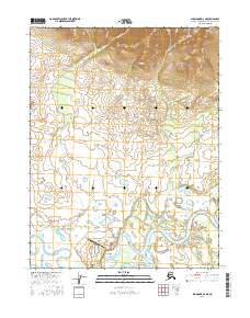
2016 Map of Shungnak D-3 NE
USGS Topo · Published 2016About this map
Shungnak sits on the northern bank of the Kobuk River, serving as a vital inland hub where the river's meandering channels meet the southern foothills of the Brooks Range. The village street plan is clearly delineated, showing Jim Street, Back Street, and 5th/Front St paralleling the water. To the west of the main settlement, the Shungnak Airport and its connecting Airport Road highlight the community's reliance on aerial transport in this roadless region.
Find a feature on this map
20 named features on this map. Tap any name to fly to it.
Don’t see what you’re looking for? This feature index may not catch every label — zoom into the map to look around manually.
Map Details
Editions of this 2016 Shungnak D-3 NE Map
This is the sole edition of this map. No revisions or reprints were ever made.
Other maps of this area

1951 · Shungnak
USGS Topo · 1:250,000

1951 · Ambler River
USGS Topo · 1:250,000

1955 · Shungnak
USGS Topo · 1:250,000

1955 · Shungnak D-2
USGS Topo · 1:63,360

1955 · Shungnak D-3
USGS Topo · 1:63,360

1956 · Ambler River
USGS Topo · 1:250,000

1964 · Shungnak
USGS Topo · 1:250,000

1964 · Ambler River
USGS Topo · 1:250,000
1985 · Ambler River A-3
USGS Topo · 1:63,360
1985 · Ambler River A-2
USGS Topo · 1:63,360