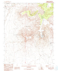
1991 Map of Shungopavi
USGS Topo · Published 1991About this map
The Hopi Indian Reservation landscape is defined by the elevation of Second Mesa, where traditional villages like Shungopavi stand as centers of cultural endurance. Based on fieldwork from 1966 and 1986, this record identifies a complex network of life-sustaining water sources scattered among the arid bluffs, including Stinkbug Spring, Bluebird Spring, and Whitewall Springs. The proximity of the Hopi Cultural Center and Hopi Civic Center to the residential clusters of Kykotsmovi and Second Mesa illustrates the integration of modern civic life within an ancestral homeland.
Find a feature on this map
34 named features on this map. Tap any name to fly to it.
Don’t see what you’re looking for? This feature index may not catch every label — zoom into the map to look around manually.
Map Details
Editions of this 1991 Shungopavi Map
This is the sole edition of this map. No revisions or reprints were ever made.
Other maps of this area

1883 · Tusayan
USGS Topo · 1:250,000

1886 · Tusayan
USGS Topo · 1:250,000

1947 · Flagstaff
USGS Topo · 1:250,000

1954 · Flagstaff
USGS Topo · 1:250,000

1958 · Flagstaff
USGS Topo · 1:250,000

1960 · Flagstaff
USGS Topo · 1:250,000

1962 · Flagstaff
USGS Topo · 1:250,000

1966 · Oraibi
USGS Topo · 1:62,500

1966 · Egloffstein Butte
USGS Topo · 1:62,500

1966 · Tovar Mesa
USGS Topo · 1:62,500