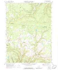
1970 Map of Shunk
USGS Topo · Published 1989About this map
The northern reaches of the Wyoming State Forest and the expansive State Game Lands No 12 dominate this high-plateau landscape along the border of Bradford and Sullivan Counties. Small crossroads settlements like Shunk, Eldredsville, and Estella anchor the rural road network, reflecting the area's long-standing reliance on timber and small-scale agriculture. The terrain is deeply incised by drainages such as Schrader Creek and Hoagland Branch, which fall away from high points like Roundtop Mtn. Local history is preserved at the Cem Elkland Meetinghouse and at formerly active nodes such as Minerville and Quinlantown. This 1970s record shows the region just before modern conservation efforts further solidified these lands as protected wilderness. Notable landmarks such as Buttermilk Falls on Fall Run and the waters of Elk Lake provide clear spatial orientation for researchers tracing the geography of the Elkland and Fox townships.
Find a feature on this map
41 named features on this map. Tap any name to fly to it.
Don’t see what you’re looking for? This feature index may not catch every label — zoom into the map to look around manually.
Map Details
Editions of this 1970 Shunk Map
Other maps of this area

1927 · Eagles Mere
USGS Topo · 1:48,000

1930 · Warrensville
USGS Topo · 1:62,500

1932 · Eagle Mere
USGS Topo · 1:62,500

1934 · Warrensville
USGS Topo · 1:62,500

1942 · Canton
USGS Topo · 1:62,500

1943 · Powell
USGS Topo · 1:62,500

1944 · Canton
USGS Topo · 1:62,500

1945 · Powell
USGS Topo · 1:62,500

1953 · Warrensville
USGS Topo · 1:62,500

1953 · Eagles Mere
USGS Topo · 1:62,500
Featured Places
- Leroy Township, PA
- Overton Township, PA
- Shunk, Fox Township
- Eldredsville, Elkland Township
- Elkland Township, PA