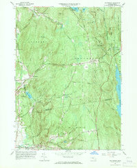
1964 Map of Shutesbury
USGS Topo · Published 1971About this map
Quabbin Reservoir defines the eastern boundary of this mid-century landscape, where the waters of the West Branch Swift River meet the edges of the Shutesbury State Forest. The map documents the transition between the agricultural and forested uplands of Shutesbury and Leverett, showing a network of small hamlets such as Locks Village and Moores Corner. Of particular historical interest are the Coke Ovens located near the northern edge of the sheet, suggesting localized industrial activity amidst the hills.
Find a feature on this map
83 named features on this map. Tap any name to fly to it.
Don’t see what you’re looking for? This feature index may not catch every label — zoom into the map to look around manually.
Map Details
Editions of this 1964 Shutesbury Map
4 editions found
Other maps of this area

1885 · Northampton
USGS Topo · 1:62,500

1886 · Northampton
USGS Topo · 1:62,500

1887 · Warwick
USGS Topo · 1:62,500

1887 · Belchertown
USGS Topo · 1:62,500

1889 · Warwick
USGS Topo · 1:62,500

1890 · Belchertown
USGS Topo · 1:62,500

1890 · Greenfield
USGS Topo · 1:62,500

1891 · Northampton
USGS Topo · 1:62,500

1893 · Northampton
USGS Topo · 1:62,500

1893 · Belchertown
USGS Topo · 1:62,500