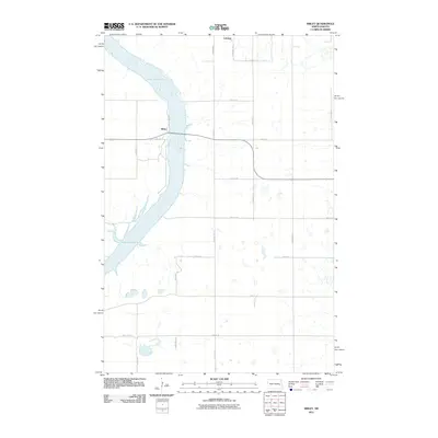
2011 Map of Sibley
USGS Topo · Published 2011About this map
Lake Ashtabula dominates the western portion of this Barnes County landscape, where the reservoir is fed by the Sheyenne River. The topography is defined by the water's edge and the surrounding plateau, where a grid of rural section roads supports the region's agricultural character. Near the northern shore, the small community of Sibley sits along the bridge crossing, while the town of Luverne is situated further north along County Hwy-25. This survey illustrates the modern configuration of the lake, which serves as a major geographical feature in an otherwise strictly surveyed prairie environment. Local transport is facilitated by a network of named routes including Elevator Rd and numerous south-east oriented streets that connect isolated farmsteads and agricultural facilities to the population centers.
Find a feature on this map
20 named features on this map. Tap any name to fly to it.
Don’t see what you’re looking for? This feature index may not catch every label — zoom into the map to look around manually.
Map Details
Editions of this 2011 Sibley Map
This is the sole edition of this map. No revisions or reprints were ever made.
Other maps of this area

1952 · Grand Forks
USGS Topo · 1:250,000

1952 · New Rockford
USGS Topo · 1:250,000

1956 · New Rockford
USGS Topo · 1:250,000

1956 · Grand Forks
USGS Topo · 1:250,000

1961 · Baldhill Dam
USGS Topo · 1:24,000

1961 · Dazey NE
USGS Topo · 1:24,000

1961 · Karnak
USGS Topo · 1:24,000

1966 · Grand Forks
USGS Topo · 1:250,000

1967 · Pillsbury SE
USGS Topo · 1:24,000
1967 · Pillsbury SW
USGS Topo · 1:24,000