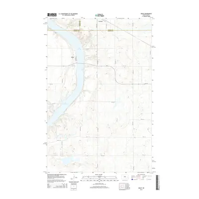
2014 Map of Sibley
USGS Topo · Published 2014About this map
Lake Ashtabula dominates the western portion of this prairie landscape, carving a significant waterway through the borderlands of Barnes, Griggs, and Steele Counties. The small settlement of Sibley occupies the western shore, served by local routes like Lake Ave and Lakeview St as they meet the water's edge. To the north, the town of Luverne sits near the crossing of several section-line roads, including 121 1/2 Ave SE and 122 1/2 Ave SE. The geography is defined by a grid of rural avenues and streets, with ND-26 providing the primary east-west corridor across the central plain. This survey illustrates a modern snapshot of North Dakota's lake-oriented recreation and agricultural transport network, where the rising terrain east of the lake is marked by numerous small depressions and wetland pockets characteristic of the region's glacial history.
Find a feature on this map
25 named features on this map. Tap any name to fly to it.
Don’t see what you’re looking for? This feature index may not catch every label — zoom into the map to look around manually.
Map Details
Editions of this 2014 Sibley Map
This is the sole edition of this map. No revisions or reprints were ever made.
Other maps of this area

1952 · Grand Forks
USGS Topo · 1:250,000

1952 · New Rockford
USGS Topo · 1:250,000

1956 · New Rockford
USGS Topo · 1:250,000

1956 · Grand Forks
USGS Topo · 1:250,000

1961 · Baldhill Dam
USGS Topo · 1:24,000

1961 · Dazey NE
USGS Topo · 1:24,000

1961 · Karnak
USGS Topo · 1:24,000

1966 · Grand Forks
USGS Topo · 1:250,000

1967 · Pillsbury SE
USGS Topo · 1:24,000
1967 · Pillsbury SW
USGS Topo · 1:24,000