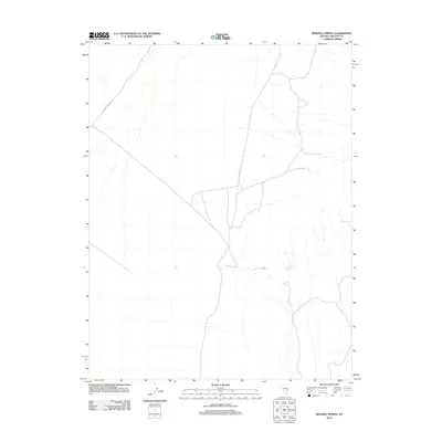
2012 Map of Sidehill Spring
USGS Topo · Published 2012About this map
Sidehill Spring and several other groundwater sources define this arid landscape in Lincoln County. The area is characterized by a network of drainage ways and unimproved tracks, with S Cave Valley Rd serving as the primary north-south artery through the valley floor. Water remains the most significant feature for any surveyor or traveler in this region, as evidenced by the naming of Jasper Spring, Mule Shoe Spring, and Cris Spring. These remote water points represent critical landmarks for land management and cattle ranching in the high desert of eastern Nevada. The map reflects a landscape where human infrastructure is sparse, limited to the essential transportation routes and the preservation of natural springs.
Find a feature on this map
5 named features on this map. Tap any name to fly to it.
Don’t see what you’re looking for? This feature index may not catch every label — zoom into the map to look around manually.
Map Details
Editions of this 2012 Sidehill Spring Map
This is the sole edition of this map. No revisions or reprints were ever made.
Other maps of this area

1956 · Lund
USGS Topo · 1:250,000

1960 · Lund
USGS Topo · 1:250,000

1969 · Shingle Pass
USGS Topo · 1:24,000

1969 · Shingle Pass SE
USGS Topo · 1:24,000

1971 · Sidehill Spring
USGS Topo · 1:24,000

1971 · Cave Valley Well
USGS Topo · 1:24,000

1971 · Sidehill Pass
USGS Topo · 1:24,000
1971 · Silver King Well
USGS Topo · 1:24,000
1973 · Grassy Mtn
USGS Topo · 1:24,000
1973 · Dutch John Mtn
USGS Topo · 1:24,000