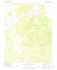
1973 Map of Grassy Mtn
USGS Topo · Published 1977About this map
Grassy Mtn and the Fairview Range dominate this landscape in Lincoln County, where the high desert terrain is punctuated by dozens of critical water sources essential for ranching and travel. The map highlights remote outposts like Meloy Ranch and Steward Ranch, illustrating the sparse but deliberate settlement pattern typical of southeastern Nevada in the early 1970s.
Find a feature on this map
26 named features on this map. Tap any name to fly to it.
Don’t see what you’re looking for? This feature index may not catch every label — zoom into the map to look around manually.
Map Details
Editions of this 1973 Grassy Mtn Map
This is the sole edition of this map. No revisions or reprints were ever made.
Other maps of this area

1915 · Bristol Range
USGS Topo · 1:62,500

1917 · Bristol Range
USGS Topo · 1:62,500

1956 · Lund
USGS Topo · 1:250,000

1960 · Lund
USGS Topo · 1:250,000
1971 · Bristol Range NE
USGS Topo · 1:24,000

1971 · Sidehill Spring
USGS Topo · 1:24,000

1971 · Bailey Wash
USGS Topo · 1:24,000
1971 · Fairview Peak
USGS Topo · 1:24,000

1971 · Sidehill Pass
USGS Topo · 1:24,000
1973 · Dutch John Mtn
USGS Topo · 1:24,000