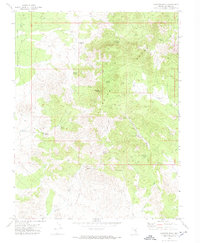
1971 Map of Fairview Peak
USGS Topo · Published 1973About this map
Fairview Peak dominates this high-altitude section of Lincoln County, Nevada, serving as the central landmark for a network of springs and mining claims during the early 1970s. The landscape is defined by the Fairview Range and the wide drainage of Muleshoe Valley, where water sources were critical to both prospecting and livestock. Named water features like Littlefield Spring, Chokecherry Spring, and Frying Pan Spring dot the terrain, often connected by rugged jeep trails. Evidence of the region's mineral history is found in the Silverhorn Mine and Robison Mine, alongside numerous unnamed prospects. The map captures a moment when the high desert economy relied on these scattered water points and small-scale excavations, with family-named landmarks like Robison Spring and Bailey Spring grounding the area's local history.
Find a feature on this map
30 named features on this map. Tap any name to fly to it.
Don’t see what you’re looking for? This feature index may not catch every label — zoom into the map to look around manually.
Map Details
Editions of this 1971 Fairview Peak Map
This is the sole edition of this map. No revisions or reprints were ever made.
Other maps of this area

1915 · Bristol Range
USGS Topo · 1:62,500

1917 · Bristol Range
USGS Topo · 1:62,500

1953 · Bristol Range SE
USGS Topo · 1:24,000

1956 · Lund
USGS Topo · 1:250,000

1960 · Lund
USGS Topo · 1:250,000
1971 · Bristol Well
USGS Topo · 1:24,000
1971 · Bristol Range NE
USGS Topo · 1:24,000

1971 · Bailey Wash
USGS Topo · 1:24,000

1971 · Sidehill Pass
USGS Topo · 1:24,000
1971 · Coyote Spring
USGS Topo · 1:24,000