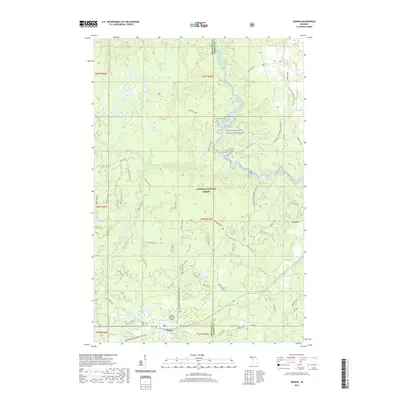
2019 Map of Sidnaw
USGS Topo · Published 2019About this map
The unincorporated community of Sidnaw anchors this portion of the Ottawa National Forest, where the border between Houghton and Baraga counties meets. This remote Upper Peninsula landscape is defined by the protected waters of the Sturgeon Wild and Scenic River, which winds through a dense network of tributaries including Sidnaw Creek and the Perch River. Local history is centered around the Sidnaw Cem and Prickett-Grooms Field, indicating small-scale settlement amid a vast wilderness dominated by timber and recreation. High ground is marked by Pine Bluff and Mt Kallio, while the lower elevations are pocketed with glacial features like Saint George Lake and Pequet Lake. A modern network of forest roads and trails, including the N Country National Scenic Trail and the Bessemer Snowmobile #8, crisscrosses the terrain, following the paths of older resource-extraction routes.
Find a feature on this map
47 named features on this map. Tap any name to fly to it.
Don’t see what you’re looking for? This feature index may not catch every label — zoom into the map to look around manually.
Map Details
Editions of this 2019 Sidnaw Map
This is the sole edition of this map. No revisions or reprints were ever made.
Other maps of this area

1895 · Perch Lake
USGS Topo · 1:62,500

1954 · Rousseau
USGS Topo · 1:62,500

1954 · Kenton
USGS Topo · 1:62,500

1954 · Perch Lake
USGS Topo · 1:62,500

1954 · Sidnaw
USGS Topo · 1:62,500

1958 · Iron River
USGS Topo · 1:250,000

1960 · Iron River
USGS Topo · 1:250,000

1961 · Iron River
USGS Topo · 1:250,000

1967 · Iron River
USGS Topo · 1:250,000
1982 · Echo Lake
USGS Topo · 1:25,000