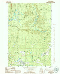
1985 Map of Sidnaw
USGS Topo · Published 1986About this map
Sidnaw serves as the primary settlement hub in this 1980s-era study of the Upper Peninsula, situated at the intersection of forest roads and the historical rail corridors that shaped the region's industry. The landscape is dominated by the Ottawa National Forest, where the complex hydrology of the Sturgeon River and its tributaries, such as Festuca Creek and Stretch Creek, carve through the timberland. Traces of the area's logging and transport history are visible in the Sid RR Grade and several segments marked as abandoned rail lines. Notable water bodies including St George Lake, Beck Lake, and Mill Lake dot the terrain south of the town. This survey also records the western boundary of the L'Anse Indian Reservation and elevation highlights like Mt Kallio, alongside several local resource sites such as the Gravel and Sand pit near the eastern margin.
Find a feature on this map
28 named features on this map. Tap any name to fly to it.
Don’t see what you’re looking for? This feature index may not catch every label — zoom into the map to look around manually.
Map Details
Editions of this 1985 Sidnaw Map
This is the sole edition of this map. No revisions or reprints were ever made.
Other maps of this area

1895 · Perch Lake
USGS Topo · 1:62,500

1954 · Rousseau
USGS Topo · 1:62,500

1954 · Kenton
USGS Topo · 1:62,500

1954 · Perch Lake
USGS Topo · 1:62,500

1954 · Sidnaw
USGS Topo · 1:62,500

1958 · Iron River
USGS Topo · 1:250,000

1960 · Iron River
USGS Topo · 1:250,000

1961 · Iron River
USGS Topo · 1:250,000

1967 · Iron River
USGS Topo · 1:250,000
1982 · Echo Lake
USGS Topo · 1:25,000