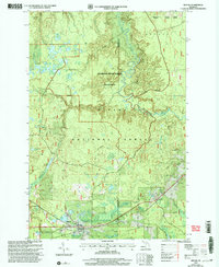
1999 Map of Sidnaw
USGS Topo · Published 2004About this map
Sidnaw serves as the primary human anchor in this northern Michigan landscape, situated at the southern edge of the dense Ottawa National Forest. The map documents a territory defined by complex hydrological networks, most notably the winding course of the Sturgeon River as it carves through the Sturgeon River Gorge Wilderness. This area, managed by the Ontonagon Kenton Ranger District, shows a clear division between preserved forest lands and industrial activity, indicated by several Gravel Pits and a Gravel and Sandpit located near the eastern boundary.
Find a feature on this map
30 named features on this map. Tap any name to fly to it.
Don’t see what you’re looking for? This feature index may not catch every label — zoom into the map to look around manually.
Map Details
Editions of this 1999 Sidnaw Map
This is the sole edition of this map. No revisions or reprints were ever made.
Other maps of this area

1895 · Perch Lake
USGS Topo · 1:62,500

1954 · Rousseau
USGS Topo · 1:62,500

1954 · Kenton
USGS Topo · 1:62,500

1954 · Perch Lake
USGS Topo · 1:62,500

1954 · Sidnaw
USGS Topo · 1:62,500

1958 · Iron River
USGS Topo · 1:250,000

1960 · Iron River
USGS Topo · 1:250,000

1961 · Iron River
USGS Topo · 1:250,000

1967 · Iron River
USGS Topo · 1:250,000
1982 · Echo Lake
USGS Topo · 1:25,000